Geostationary Earth Orbit (GEO): An Overview
What is a GEO? Why is it considered a space choke point? What do we use it for? Why do other orbits complement it? Highly Elliptical, Tundra, Polar and Sun-Synchronous Orbits explained.


1. Geostationary Earth Orbit (GEO)
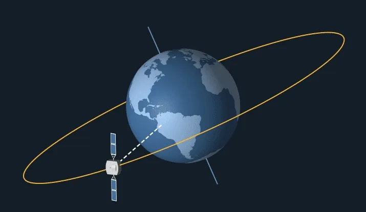
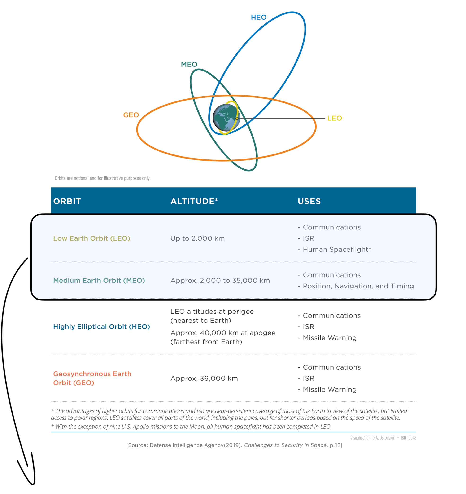
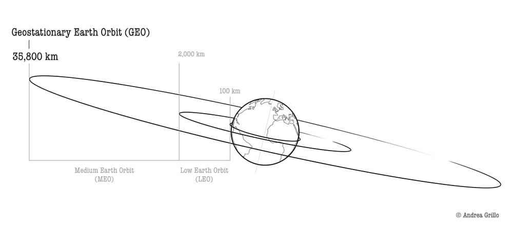
Orbits with a period equal to that of the Earth - 23 hours 56 minutes 4 seconds - are called geosynchronous and are located at an altitude of approximately 35,800 km (Figure 1) (Gray & Sloan, 1999, p.89). The geosynchronous orbit whose orbital plane lies on the Earth's equatorial plane (inclination=0°) is not affected by the Earth’s rotation, meaning that a satellite in this orbit appears stationary relative to a fixed point on the Earth's surface. Such an orbit is thus called a Geostationary Earth Orbit (GEO). This phenomenon occurs because the satellite orbits the Earth with the same angular velocity and in the same direction as the Earth's rotation.

1.1. GEO Advantages
Fixed Position Relative to the Ground
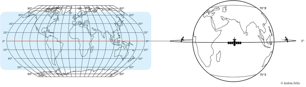
A satellite in GEO appears as a fixed point in the sky to observers on the ground (Figure 2). As a result, users only require ground-based stationary antennas to send or receive signals from the satellite, eliminating the need for tracking equipment (Wright et al., 2005, p.43). Moreover, this characteristic makes it an excellent choice for meeting specific regional geographical requirements, as the satellite remains fixed over a designated region.
Wide Field of View
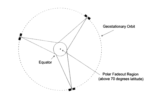
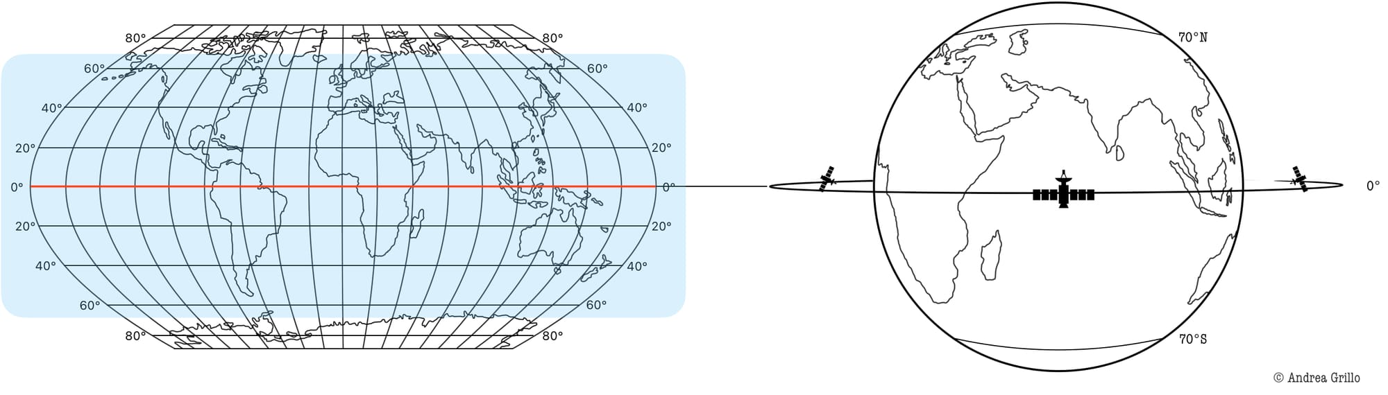
Due to the satellite's high altitude, it has a wide field of view, covering about 43% of the Earth's surface. This provides visibility between 70° North and South latitude, leaving only the poles and portions of Scandinavia, Russia, and Canada uncovered. Therefore, by deploying just “three satellites at geostationary orbit, carefully placed equidistant from each other, [one] can view the entire planet up to approximately 70° north or south latitude”, thus reaching near-global coverage (Figure 3; Figure 4) (Gray & Sloan, 1999, p.89). One technique to overcome this deficiency is through three to six satellites orbiting in Highly Elliptical Orbit (HEO) to provide continuous communication.
For these reasons, geostationary orbit has been the preferred choice for telecommunications satellites, such as those used for television and radio broadcasting. Indeed, a single satellite can provide full coverage of a nation, making it a cost-effective and efficient solution for telecommunications infrastructure. Until a few years ago, practically all communication satellites were in GEOs. Today things are changing in favor of Very Low Earth Orbits (VLEO).
1.2. GEO Downsides
High Latency
“The round-trip transmission time [i.e. latency] between a ground station and a satellite is the distance traveled divided by the speed of light” (Wright et al., 2005, p.36). In the case of a GEO satellite, this time amounts to roughly 0.25 seconds. At first glance, it may seem negligible, but the International Telecommunication Union (ITU) recommends keeping latency below 0.3 seconds for voice calls, as exceeding this threshold can severely degrade call quality, leading to distorted and unproductive conversations (Kelleher, 2024). Moreover, when compared to the latency of LEOs, which averages around 0.005 seconds, this is approximately 50 times higher.
Possible Interferences Due to High Demand
Being unique in its characteristics, this orbit is heavily populated, especially in some densely populated regions such as Europe, North America, and Asia, where numerous operators want to place their satellites. This can lead to potential signal interference between satellites. To prevent overlapping frequencies the International Telecommunication Union (ITU) is responsible for assigning satellite positions and frequencies, ensuring that transmitted signals do not interfere with one another (Wright et al., 2005, p.36).
Single point of failure (SPF)
In any system that is completely reliant on the operation of a single satellite, the latter represents its critical component, also referred to as “single point of failure”. In this scenario, all operations, such as communications, data transmission or broadcasting services, depend on its functioning. If the satellite fails or is attacked, there is no immediate alternative unless there are other operational satellites or a backup plan.
1.3. GEO Applications
Geostationary earth orbits (GEOs) are valuable for a wide range of applications due to their unique characteristics of fixed positioning relative to the Earth's surface, which allows for continuous coverage, and a wide field of view.
One of the primary applications of GEO satellites is in telecommunications, where they deliver uninterrupted signal transmission. This is especially critical in areas lacking terrestrial infrastructure, such as remote regions, oceans, or disaster-stricken zones, ensuring continuous communication for internet and phone services. Additionally, geostationary satellites play a major role in television broadcasting.
Another important application of GEO satellites is in meteorology. Their ability to monitor a vast and consistent geographic area makes them invaluable for weather forecasting and atmospheric studies. Satellites such as those operated by the US National Oceanic and Atmospheric Administration's Geostationary Operational Environmental Satellite programme - NOAA’s GOES programme - provide continuous real-time imagery and data for predicting storms, tracking hurricanes, analysing long-term climate patterns, and environmental monitoring (Dick, 2015, p.472).
Regarding navigation, China's BeiDou GNSS and India's NavIC regional navigation systems leverage GEO satellites to enhance their performance and reliability. Similarly, systems such as the European Geostationary Navigation Overlay Service (EGNOS), the US Wide Area Augmentation System (WAAS), India’s GPS Aided Geo Augmented Navigation (GAGAN), and Japan’s Multi-functional Satellite Augmentation System (MSAS) are designed to enhance the accuracy and reliability of GNSS signals within their respective regions of interest. These services serve particular domains such as aviation, maritime operations, and precision agriculture requiring accurate location information (Cayón Peña, 2022, p. 17; European Commission).
2. Highly Elliptical Orbit (HEO)
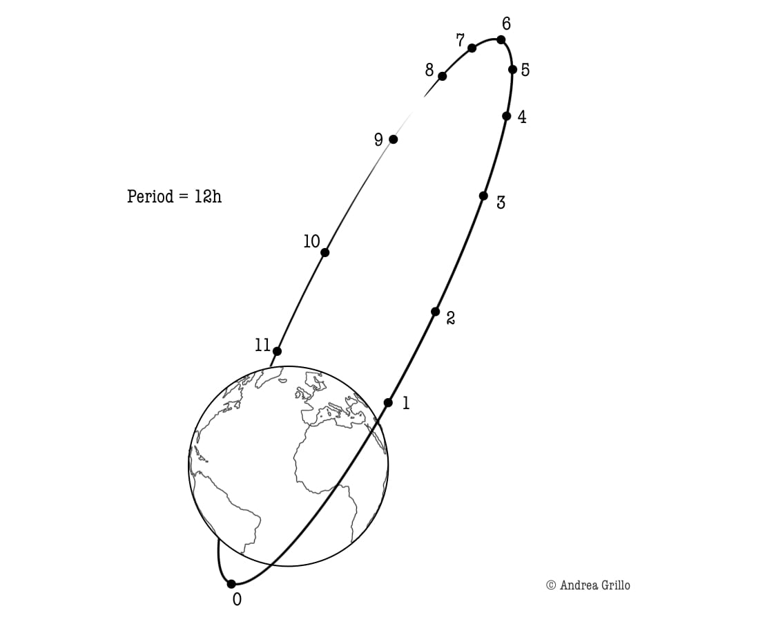
Highly Elliptical Orbits (HEOs) are extremely elliptical and inclined orbits (63.4° of inclination). These characteristics are directly related to their use. Also called Molniya orbits, because of the Molniya Soviet communications and weather satellite system that first used them, they cover areas above 70° latitude, which geostationary orbits are unable to reach. HEOs have an apogee of 40,000 km (3,000 mph speed) and a perigee of about 1000 km (20,000 mph speed), which makes the satellite appear “to dwell over the upper latitudes for several hours, making this a particularly useful orbit for communications satellites servicing arctic regions”: with only three satellites continuous coverage of this area can be ensured (Figure 5) (Gray, & Sloan, 1999, p.89). Molniya orbits are also used today “by U.S. intelligence satellites that monitor Russia and by Russian early warning satellites that watch for U.S. missile launches” (Wright et al., 2005, p.43).
3. Tundra, Polar and Sun-Synchronous Orbits
Tundra orbits are similar to Molniya orbits in that they have the same inclination but are less elliptical, and their period is 24 hours instead of 12. This means that continuous coverage of the region can be achieved with only two satellites, as done by the Russian Tundra system (Wright et al., 2005, p.43).
Polar orbits are a type of LEOs that pass over Earth's polar regions, very close to the poles, from north to south, and are thus almost perpendicular to the equatorial plane (96-98° of inclination) (Wright et al., 2005, p.44). The peculiarity of this orbit is that it has coverage over the entire Earth (obviously not continuous).
A special Polar LEO is the Sun-Synchronous Orbit (SSO) located between 600 and 800 km altitude (ESA, 2020). Satellites in SSO “pass over a given part of the Earth at roughly the same local time of day” (Wright et al., 2005, p.44). This characteristic allows for images to be collected without changing shadows. This is why SSO is “one of the most important [orbit] for military reconnaissance and weather imaging […] for satellite cameras that takes images in the visible light spectrum and for satellites that require continuous solar access for power” (Gray, & Sloan, 1999, p.101).
📌 Key Takeaways
- Geostationary Earth Orbit (GEO): approximately 35,800 km altitude, with a period matching Earth's rotation, appearing stationary to ground observers.
- GEO Advantages: Fixed position enables consistent coverage of a specific region, making it ideal for region-focused missions. GEO satellites cover 43% of Earth's surface, thus three satellites can provide global coverage up to 70° latitude.
- GEO Downsides: High latency can impact real-time communication. Signal interference due to high demand. Single point of failure requires backups or redundancy for critical operations.
- Applications of GEO Satellites: Telecommunications (Internet, phone services, and TV broadcasting) Meteorology (weather forecasting and monitoring) Navigation (enhance regional navigation systems) Environmental Monitoring.
- Highly Elliptical Orbits (HEO): Elliptical and inclined orbits (63.4°) suited for polar and high-latitude regions coverage, complementing GEO satellites.
- Sun-Synchronous Orbits (SSO): Special Polar orbit (inclination 98°) providing global coverage and light-consistent imagery.
References 📃
Defense Intelligence Agency (2019). Challenges to Security in Space.
Cayón Peña, J. (2022). Security and Defence: Ethical and Legal Challenges in the Face of Current Conflicts. Springer International Publishing AG.
Chapter 5: Planetary Orbits - NASA Science. (n.d.). NASA. Retrieved 17 January 2025, from https://science.nasa.gov/learn/basics-of-space-flight/chapter5-1/
Dick, S. J. (2015). Historical Studies in the Societal Impact of Spaceflight. National Aeronautics and Space Administration (NASA).
EGNOS | Satellite Navigation—European Commission. (n.d.). European Commission. Retrieved 21 January 2025, from https://defence-industry-space.ec.europa.eu/eu-space/egnos-satellite-navigation_en
Gray, C. S., & Sloan, G. (1999). Geopolitics, Geography, and Strategy. Frank Cass.
Kelleher, L. (2024, March 12). Are You Measuring Latency on Your Calls? Cyara. https://cyara.com/blog/measuring-latency-on-your-calls/
Polar and Sun-synchronous orbit. (2020, March 2). [Official Website]. ESA. https://www.esa.int/ESA_Multimedia/Images/2020/03/Polar_and_Sun-synchronous_orbit
Wright, D., Grego, L., & Gronlund, L. (2005). The physics of space security. A Reference Manual.
Keep Learning

