Into the Void: How Countries Choose Their Satellites' Orbits
Why Satellites Are Where They Are? What are the Key Factors to Consider when Positioning Satellites? How do you Choose an Orbit? From Gathering High-Resolution Images to facilitating Global Communications, each Satellite's Orbit is Designed to Optimise its Functionality.

How Countries Choose Their Satellites' Orbits
Although space is like an ocean and therefore can be travelled in all directions, due to gravity, the paths that satellites can navigate are limited to orbits. However, even the choice of orbits is not arbitrary and must take additional factors into account. Not all orbits possess the same characteristics, and not all are actually passable.
“The choice of a particular orbit for a satellite depends mainly on its mission” (Wright et al., 2005, p.29).
...
This article outlines the constraints that must be taken into account when placing a satellite in space. These depend mainly on its mission and the Earth area that the satellite is to serve.
When choosing an orbit, the most significant parameters to take into account are
- the altitude of the orbit and
- its inclination angle.
As these two parameters vary, the orbit has different characteristics and lends itself to satellites for different uses.
- The satellite's field of view should also be carefully considered not only due to the movement of the satellite itself but also due to the Earth's rotation.
- Finally, not all orbits are free to be exploited due to space congestion and space weather.
1. Altitude
The satellite's orbit altitude is defined strictly by its mission.
- Satellites whose purpose is to gather high-resolution images (ISR Satellite) are required to be close to Earth and therefore need to be in a low-altitude orbit.
- On the contrary, telecommunication satellites (SATCOM), which require sending and receiving signals over a wide geographical region, ought to be placed at greater altitudes to have broader observable ground area and thus wider antenna coverage for their operations (Wright et al., 2005, p.34) (Figure 1).
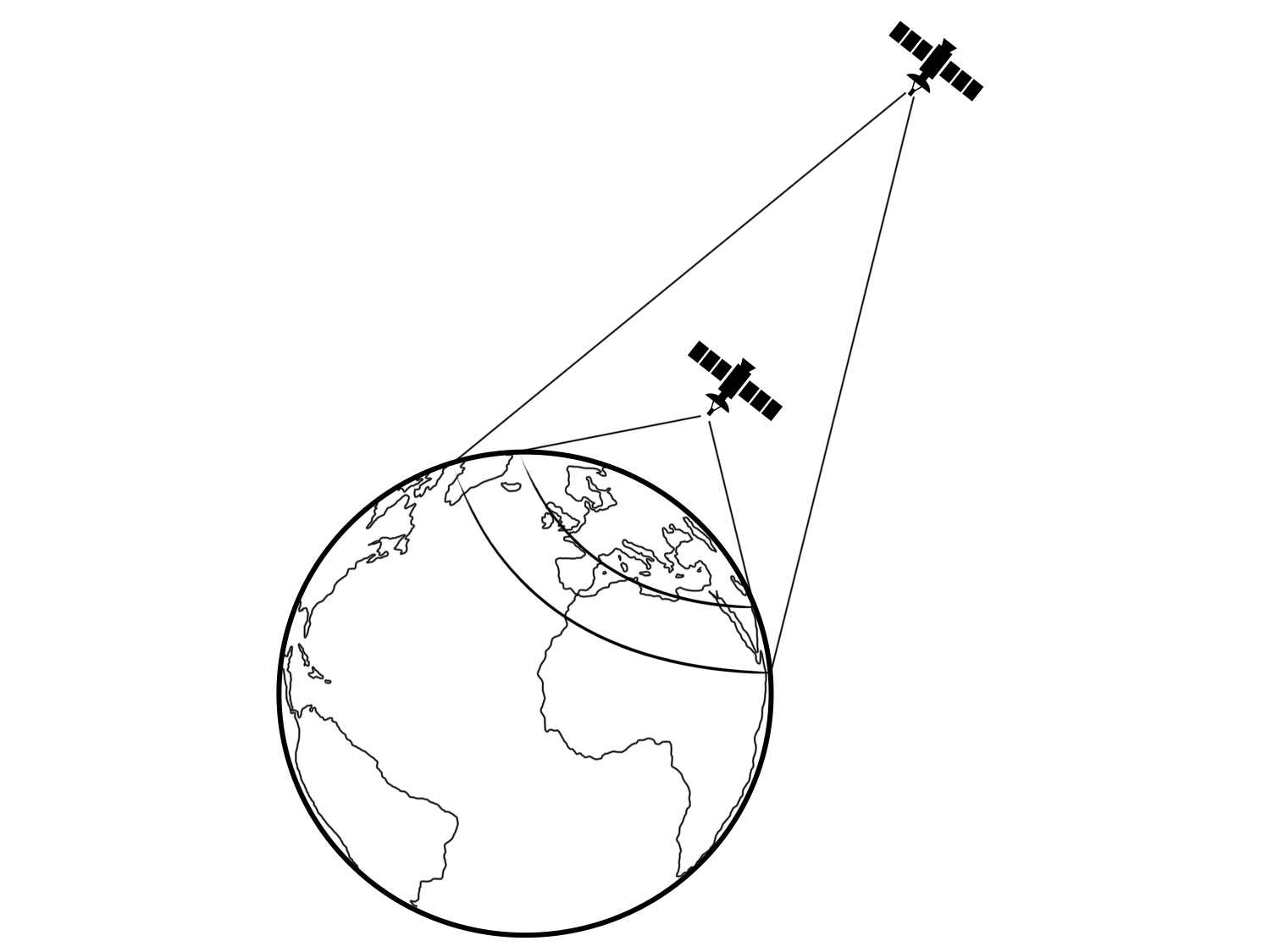
Another influential factor to take into account is the capacity of the sensors which the satellites are equipped with. For example, for a reconnaissance satellite in low orbit, the real observable area is only about half of what is actually under its visibility (Wright et al., 2005, p.34).
However, this must be balanced against the fact that using higher orbits “may be impossible for some applications, such as high-resolution surveillance or ballistic missile defense, which requires space-based interceptors to be relatively close to attacking missiles” (Wright et al., 2005, p.36). Higher orbits also face the problem of visual distortion because of atmospheric density.
2. Orbital Plane Inclination
The inclination of the orbital plane affects the Earth area that the satellite passes over and can thus observe and over which it can transmit.
An illustrative example is that of Russia. Most of its territory is indeed located at high latitudes, between 50° and 80°. For telecommunications and territorial monitoring, Russia thus needs satellites that cover those specific latitudes. A satellite with a 40° inclination would not be capable of such a mission, as it would never fly over the country (Figure 2).
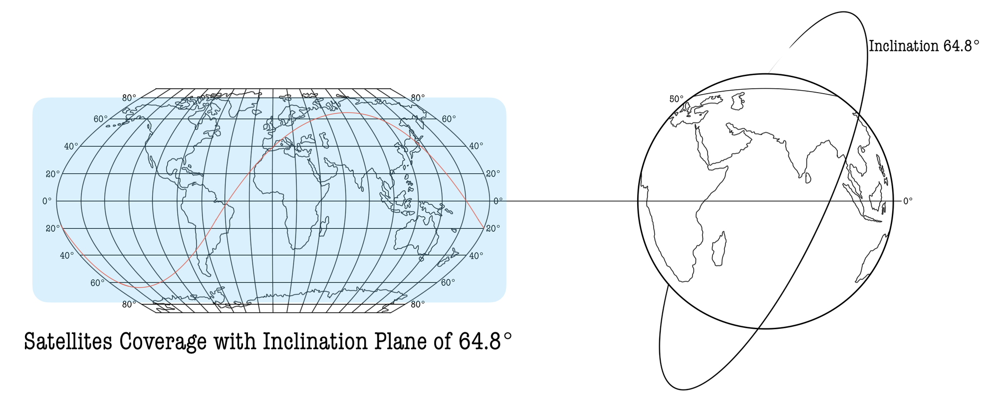
Therefore, most Russian satellites operate at inclinations above 60°. The Russian GLONASS navigation system, for instance, is operated by satellites with an inclination of 64.8° as opposed to the American (GPS) and European (Galileo) ones, which have inclinations of 55° and 56° respectively (GLONASS Space Segment, n.d.) (Figure 3).

3. Field of View
When choosing the orbit of a satellite, it must also be considered that they constantly vary their Field of View (FOV or swath width) (Figure 4).
- This is true with the exception of geostationary orbits (0° inclination), which are always above the same point on Earth, and polar orbits (90° inclination), passing over the poles every period.
- Orbits with an inclination angle greater than 0° will see the Earth rotate underneath in addition to their orbital motion.
Consider a satellite in low orbit with an inclination of 40° that takes 90 minutes to complete one revolution (period = 90 minutes). The equatorial Earth below rotates about 2,500 km in 90 minutes. After 90 minutes, therefore, the satellite will not be at the same point as before with respect to the Earth, but 2,500 km west from it (Figure 4) (Wright et al., 2005, p.30). On top of this, the satellite remains in view of a point for a short time, approximately 10 minutes.

It goes without saying that a constellation of satellites is required to have a continuous view of a point on Earth.
The number of satellites required for continuous coverage also depends on the altitude of the satellite orbit: “the higher the orbit, the larger the ground area that the satellite can observe and communicate with”(Wright et al., 2005, p.35).
Finally, it is worth mentioning the existence of the so-called five Lagrange points, i.e., points in space where the gravitational effects of the Earth and the Moon cancel each other out, which allows an object to theoretically remain stationary with no fuel consumption. However, due to “solar flares, orbital drift and wobble, and micrometeorites, only two of the Lagrange points are effectively stable” (Dolman, 2005, pp.65-66).
4. Congestion and Space Weather
When it comes to telecommunication satellites the main issues are interferences and antenna coverage.
- Interferences are due to several satellites in space using the same transmission frequencies which could therefore interfere with each other. In order to avoid overlapping frequencies, especially in the unique and densely populated geostationary orbit, the International Telecommunication Union (ITU) performs the task of assigning positions and frequencies, so that their transmitted signals do not interfere with each other (Wright et al., 2005, p.36).
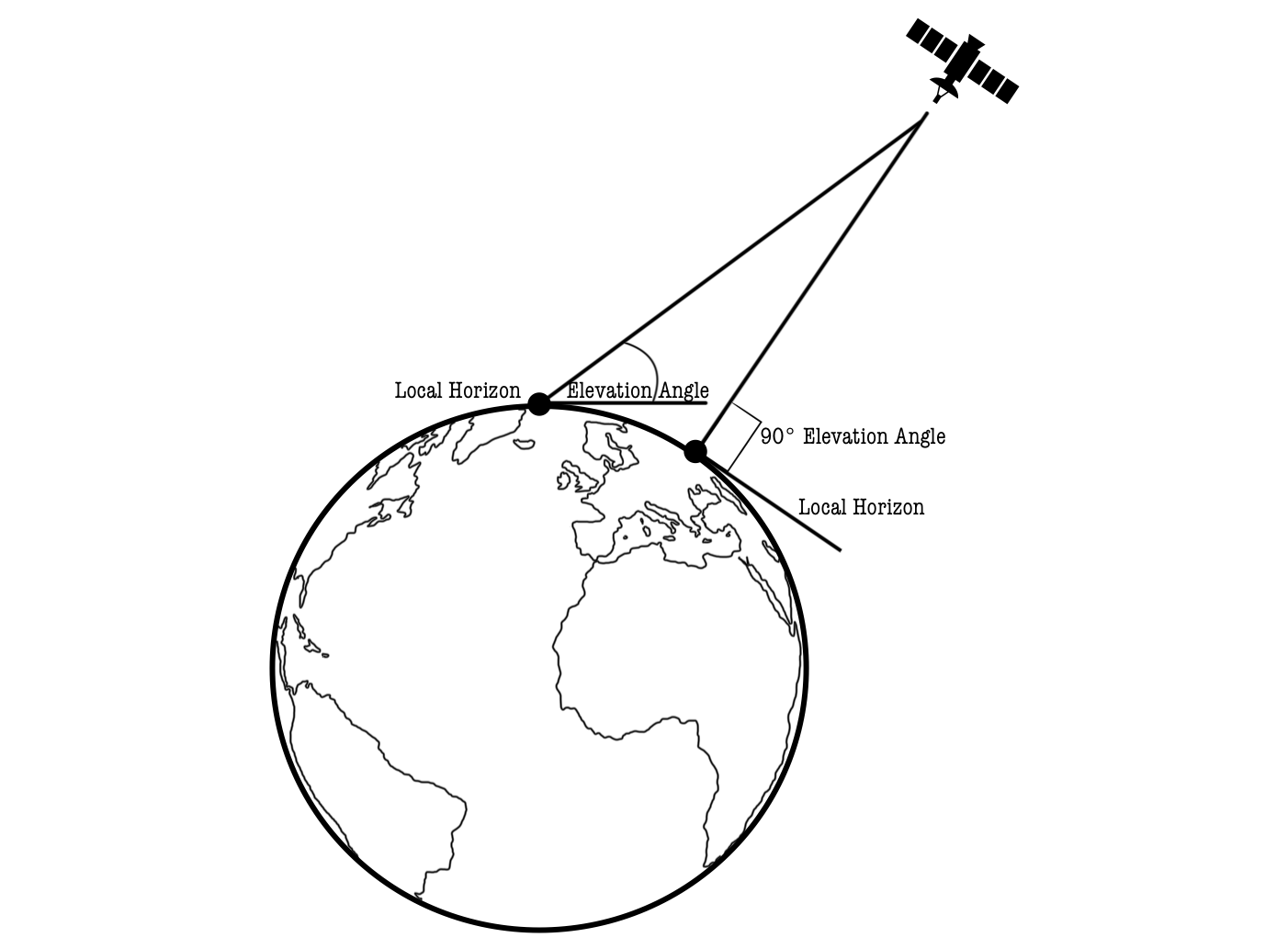
- Second, the constraint of antenna coverage depends on the technology adopted, the height of the satellite, and the lay of the land over which it is to transmit. Covering highly mountainous terrain or cities with particularly tall buildings is more difficult than covering a flat landscape. In an ideal scenario, the satellite should be perpendicular to the terrain (elevation angle 90°) to transmit data effectively so that such obstacles do not block the signal (Figure 5) (Wright et al., 2005, p.33)
Furthermore, in space, being a radioactive environment, positively or negatively charged particles exist - also referred to as space weather - that might damage or degrade satellite components as well as cause mortal injury to astronauts. These particles are located in specific parts of outer space, i.e., Van Allen radiation belts, which are therefore unusable (Gray & Sloan, 1999, p.98).
📌 Key Takeaways
When a country launches a satellite, its orbit is tailored to its mission objectives, dictating the area of Earth to be observed and the intended purposes. The altitude and inclination of the orbit are defined accordingly.
- The altitude dictates the width of the satellite’s field of view and its observation capabilities.
- The inclination angle influences the overall Earth area a satellite can observe and transmit over.
Furthermore, it must be considered that:
- A satellite constellation is required for continuous visibility or communication at a given location since the satellite's field of view varies continuously. The number of satellites needed for continuous coverage depends on orbit altitude.
- Not all orbits are available due to the presence of other space actors' satellites - space environment congestion - which, along with space weather, causes interference in transmissions to Earth.
References 📃
- Dolman, E. C. (2005). Astropolitik: Classical geopolitics in the space age. Routledge.
- GLONASS Space Segment (n.d.). ESA Navipedia. Retrieved 18 March 2024, from https://gssc.esa.int/navipedia/index.php/GLONASS_Space_Segment
- Gray, C. S., & Sloan, G. (1999). Geopolitics, Geography, and Strategy. Frank Cass.
- Wright, D., Grego, L., & Gronlund, L. (2005). The physics of space security. A Reference Manual.

