Israel’s Defensible Borders: The Crucial Role of Geography
Why does Israel still retain control over the Golan Heights and the West Bank in violation of International Law? What role does Geography play in all this? A Security and Military Perspective.
Israel’s Defensible Borders: The Crucial Role of Geography
Israel’s geography has affected agricultural, economic, and technological advancements, influencing settlement patterns and population distribution. The Mediterranean coastline has fostered trade and cultural exchange, while the desert regions have been a challenge for settlement and development. Limited water resources and arable land have spurred innovations in water management, agriculture, and sustainability that are closely watched and emulated worldwide.
Nevertheless, the country’s extraordinary development, efficiency and technological advancement have been urged and imposed mainly by one factor: its perpetual state of war.
From the arid expanses of the Negev Desert in the south to the fertile plains of the Galilee in the north, from the flow of the Jordan River in the east to the Mediterranean Sea’s expanse to the west, the Land of Israel has been a battleground since its foundation. These very same wars shaped its borders and influenced its security strategy.
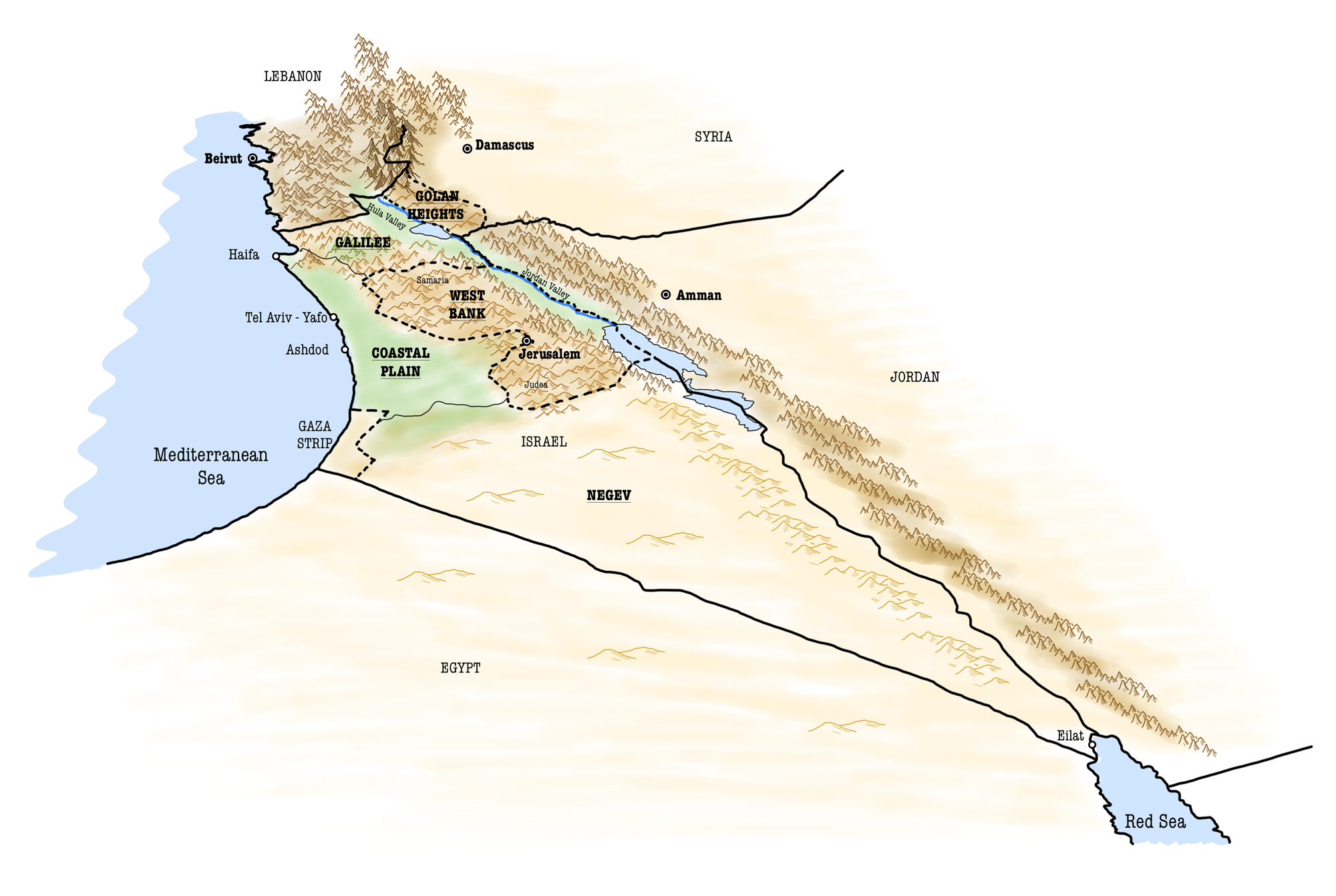
The nation offers a unique case study of how natural landscapes can defend or expose a country to enemy attacks, and thus influence its security policy and boundary shifting.
The shapes of Israel’s modern borders result from historical conquests, negotiations, and conflicts, all deeply influenced by the country’s geography. These natural features have not only provided natural defence barriers but have also facilitated and constrained the movement of peoples, goods, and armies, shaping the socio-political landscape of the region (Map 1).
...
This article analyses the different regions that make up the State of Israel today according to their geopolitical role. The area under analysis is not the one under the internationally recognised borders, but the de facto borders, i.e. the territories over which Israel exercises direct control.
In particular, the issue at stake is:
Why does Israel persist in controlling the Golan Heights and the West Bank?
Following the 1967 Six-Day War, in which Israel emerged victorious against the Arab coalition of Syria, Jordan and Egypt, Israel seized the Golan Heights from Syria, the West Bank from Jordan, and the Sinai Peninsula and the Gaza Strip from Egypt, thus quadrupling its territorial extension. However, in 1982, through a peace agreement, Israel withdrew from the Sinai Peninsula, handing it back to Egypt. Then why has it not replicated this approach with the other captured territories, which remain under Israeli control to this day?
To explore this issue, a security and military-focused perspective will be adopted. Specifically, a geopolitical analysis of the regions constituting the State of Israel will be conducted to highlight both their military and economic significance.
- First, the Coastal Plain, the Negev, and the Galilee - regions where under international law the State of Israel is entitled to stand - will be analysed.
- Second, attention will turn to the Golan Heights and the West Bank.
- Finally, the findings of this research will be drawn.
For the purposes of this research, the Gaza Strip will not be taken into consideration. This region has been indeed under Israeli occupation from 1967 until 2005 when Israel withdrew from its territory.
1. The Coastal Plain
The Coastal Plain of Israel holds significant importance due to its geographic location, economic activities, and demographic concentration.
This area stretches along the Mediterranean Sea, from the Gaza Strip in the south to the northern border with Lebanon. The eastern part is marked by the Judea Mountains, where the West Bank begins. Being thus squeezed by the mountains to the east and north and the Negev desert to the south, this region is characterized by dense population centres, fertile land, and strategic ports (Orni & Efrat, 1977).
- Almost “three-quarters of the population of Israel”, approximately 6.3 out of 9.3 million, lives in the region (Dayan,1955, p.250; Total population of Israel 2021, by district, n.d.).
- The Coastal Plain plays a critical role in Israel’s agriculture and water management. The region’s fertile soil and favourable climate support a variety of crops, contributing to the country’s food security. Moreover, initiatives such as desalination plants along the Mediterranean coast are vital for addressing Israel’s water scarcity challenges, highlighting the region’s importance in sustainable resource management (Gradus et al., 1993).
- The Coastal Plain is thus the economic heartland of Israel, hosting the majority of the country’s industrial activities, agricultural production, and service sectors. Cities like Tel Aviv, Haifa, and Ashdod host major international airports and seaports that are crucial for international trade (Gradus et al., 1993).
Being the epicentre of political, financial, industrial, and cultural life, the Coastal Plain represents the heart of Israel which must therefore be defended.
1.1. Security concerns
From a military perspective, several considerations must be made (Map 2).
- First, the Coastal Plain houses several key military and critical industrial facilities, making it a strategic asset. The production centres of Haifa and Tel Aviv host the country’s most important industrial, military and high-tech hubs (Gradus et al., 1993).
- Second, the proximity of this region to the Mediterranean Sea also has implications for Israel’s navy and its ability to project power and protect its maritime borders.
- Above all, the Coastal Plain, and thus Israel, lacks strategic depth.
At its narrowest point, the Coastal Plain measures no more than 14 kilometres (8.5 miles) with “an average width of no more than twelve miles [19 km] between the Mediterranean and the Jordanian border [today’s West Bank]” (Dayan, 1955). To provide a measure of comparison, this is less than a 10-minute drive at 130 km/h (80 mph) or as much as 1/4 the diameter of the city of London.
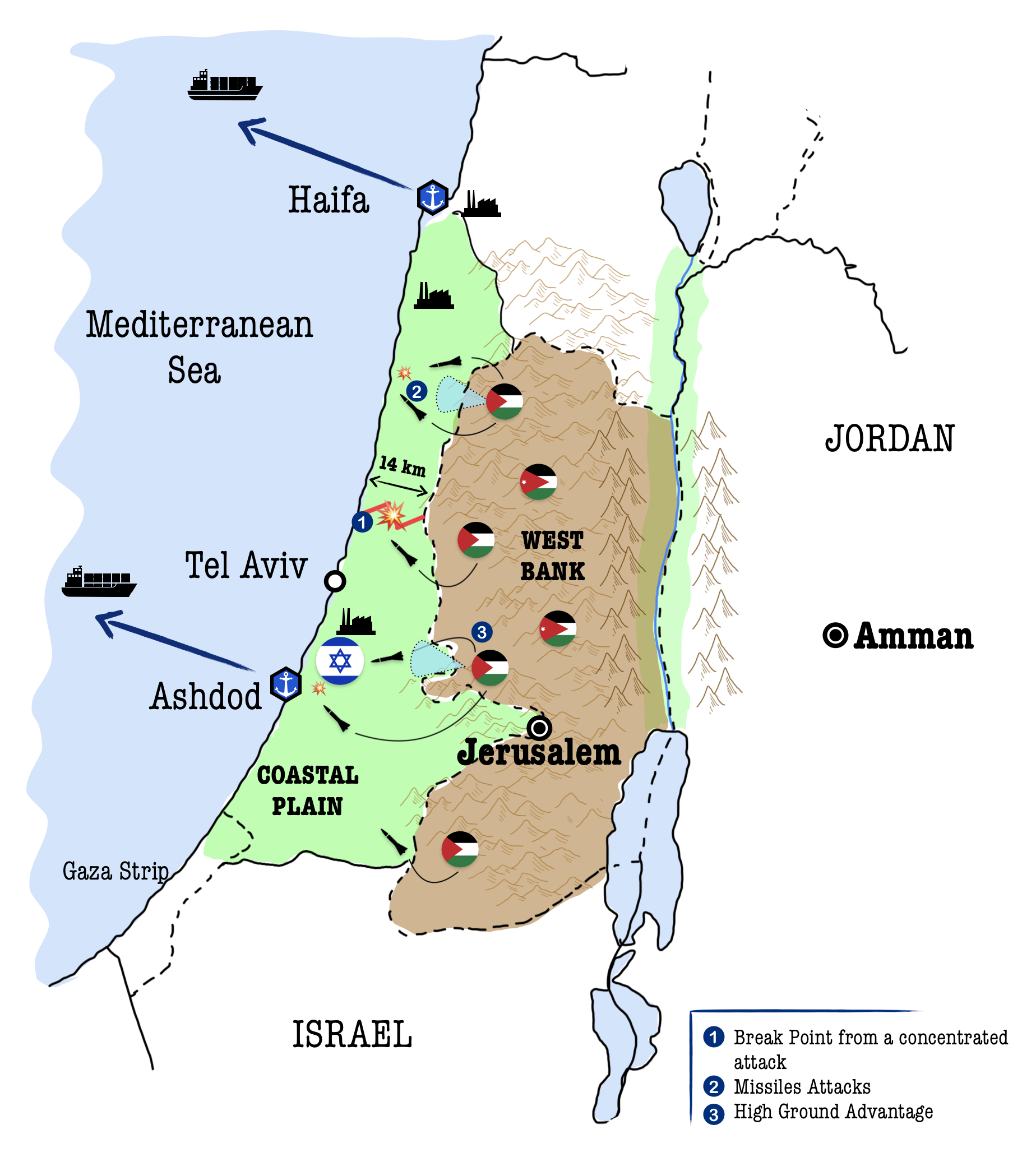
- First, this implies that a single concentrated attack by a determined military force could easily divide the core and the entire nation into two.
- A second concern arises with regard to missile attacks. Modern missile weapons allow the enemy to hit all coastal plain population centres in a matter of seconds. Following uninterrupted missile attacks, reaching peaks of 600+ rockets and mortar shells per month, Israel built the world’s most advanced anti-missile defence system, the Iron Dome (Baron et al., 2018). The system is designed to intercept and destroy short-range rockets and artillery shells fired from distances between 4 and 70 kilometres (Shapir, 2013). For instance, such a defence system allowed Israel to defend its civilians from the missiles launched on October 7, 2023, when a hail of 2,200 missiles according to the IDF, and 5,000 according to Hamas, was fired on this strip of land within a few hours (McKernan, 2023). Nevertheless, Iron Dome has a success rate of 70% to 90%, not to mention that the entire land under 4 kilometres would be impossible to protect from such an attack (Shapir, 2013).
- Third, in addition to the lack of strategic depth, the topography of the terrain makes this position inherently complex to defend. The flat terrain of the Coastal Plain contrasts with the more mountainous regions to the east, namely the West Bank, giving the enemies the advantage of high ground.
In this narrow strip of land squeezed between the sea to the west and the mountains to the east, defence is therefore almost inconceivable against surprise attacks, being as catastrophic as fatal for the State of Israel.
2. The Negev
South of the Coastal Plain lies the Negev region. The Negev is shaped like a triangle whose sides are the southern border with the Egyptian Sinai Peninsula, the Arava Valley on the border with Jordan to the east and the regions of Judea and Samaria - namely the West Bank - and the Coastal Plain to the north. Although the region accounts for 60% of the territory within Israel’s international borders, it only has 1 million inhabitants due to its predominantly mountainous and desertic morphology (Orni & Efrat,1977, p.15).
At first glance, it might seem that the region is of little strategic value.
However, it must be considered that international trade access to eastern markets passes through the Red Sea. Israel can potentially access this sea either through ports on the Mediterranean coast via the Suez Canal, or through the Gulf of Aqaba and its Strait of Tiran to the south. In the far south of the region, lies indeed the city of Eilat, which by means of its seaport situated on the shores of the Gulf of Aqaba, offers Israel critical access to the Red Sea should there be a blockade of the Suez Canal.
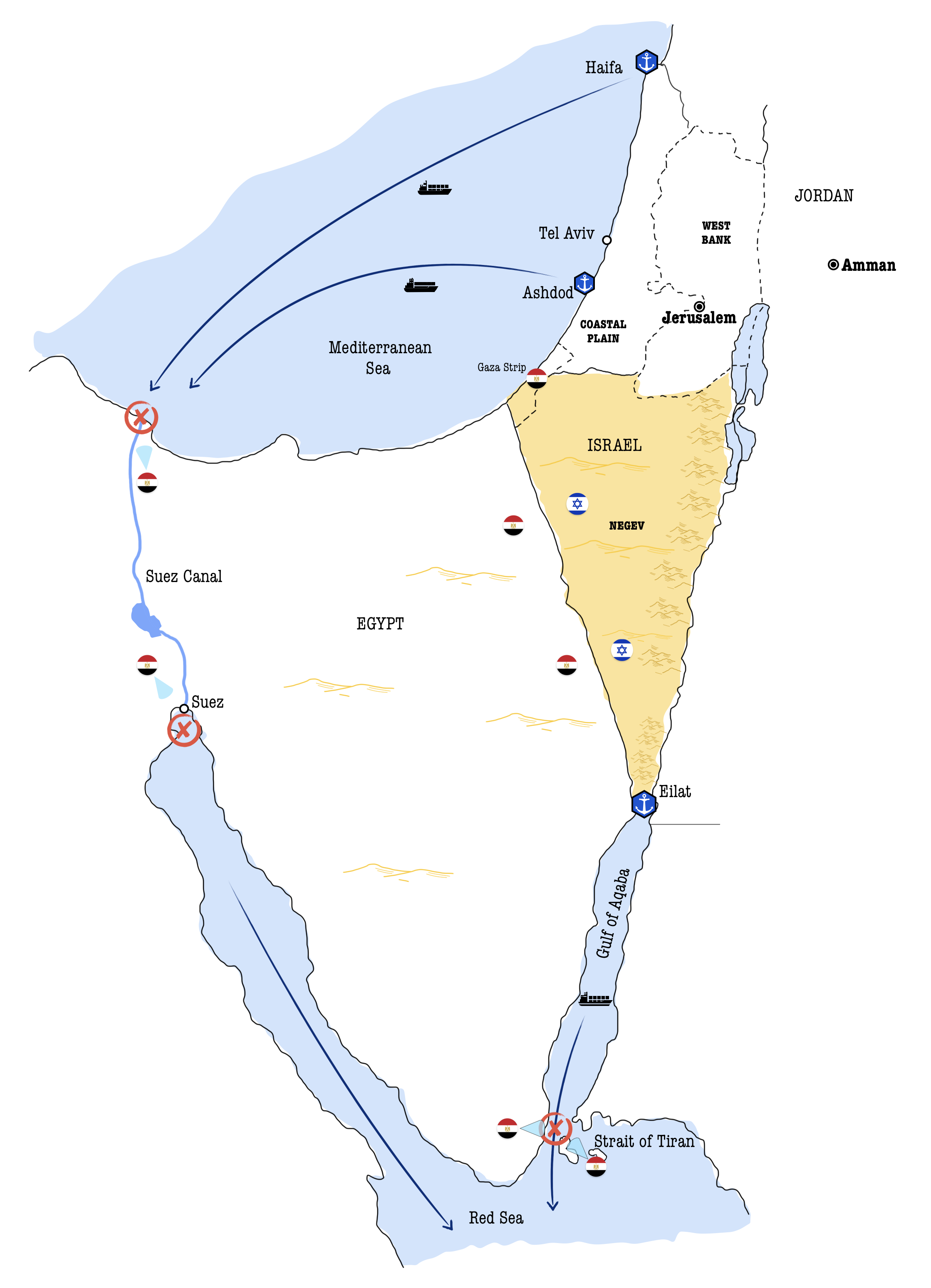
- This position has historically proved to be strategically important for the State of Israel, which has indeed seen the passage of its ships through the Suez Canal denied by Egypt for much of the time between Israel’s declaration of independence in 1948 and the 1967 Six-Day War (Map 3).
- Nevertheless, it is important to bear in mind that also Israel’s access to the Red Sea through the Eilat Port has nonetheless been under Egyptian control. Egypt has periodically closed this access by blocking the Straits of Tiran, which connects the Gulf of Aqaba to the Red Sea.
Therefore, the Negev region, through the city of Eilat, is strategically relevant, allowing Israel to have a direct communication link with the Red Sea and the countries beyond the Indian Ocean, thus providing backup access to international markets should there be a crisis involving the Suez Canal (Orni & Efrat,1977, p.15).
3. The Galilee
The last of the regions to fall within the internationally recognised borders of Israel is the Galilee, which borders Lebanon to the north, the West Bank to the south, and should touch Syria to the east.
The Galilee is important for its natural resources and fertile land for agriculture. The region is home to Israel's most important water bodies, the Jordan River, and the Sea of Galilee. The Israel Northern District, which encompasses the entire Galilee, houses 1.5 million Israelis, placing it as the second most populous region after the Coastal Plain (Total population of Israel 2021, by district, n.d.). These reasons make it a crucial region for the survival of the State of Israel.
From a topographical perspective, the Galilee can be divided into two macro-areas: Western and Eastern Galilee. While the first one is predominantly hilly, extending westward from the eastern valleys to the sea, the second is a plain area, often referred to as the finger of Galilee due to its distinctive shape (Inbar, 2011, p.7).
- The northern border of the region extends along Lebanon, the homeland of Hezbollah, which since its emergence has continuously carried out rocket attacks against Israel. Nevertheless, “due to its topography, Israel’s northern border lies on relatively good defensible ground” (Eshel, 1997, p.228). Indeed, thanks to the hilly land, some observation points and a sophisticated protective barrier, security of the Western Galilee against hostile infiltration is ensured.
- The most challenging border is the Eastern Galilee. The Hula Valley is, in fact, the Achilles heel of Israel’s north-eastern border. This valley is surrounded by mountains to the west and the east and borders the Majayun Valley to the north.
- The Majayun Valley opens thus the door to Lebanon’s attacks in the far north of the Israeli border, also being able to rely on an advantageous observation and support base provided by the western high ground (Eshel, 1997, p.228).
- The eastern side of the valley, however, is even worse. To the east lies the Golan Heights, which, as the name suggests, is a sloping plateau with an extension of 20/25 km further east. The difference between the 200m below sea level of the Jordan Rift and Hula Valley and the 300m of the Golan Plateau, means that there is a very steep gradient of about 500m right at the internationally recognised 1949 border between Israel and Syria (Inbar, 2011).
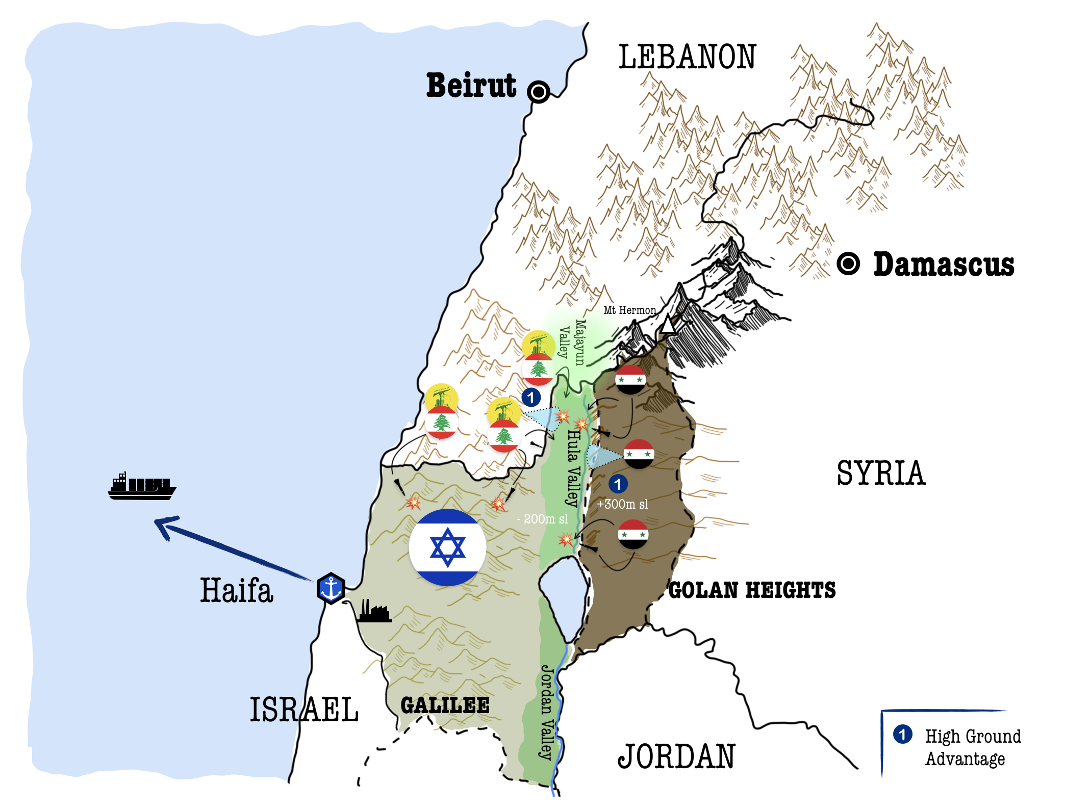
The situation is so militarily disadvantageous that the Galilee Panhandle results in a
“defender’s nightmare, with its open access to anyone coming from the north or east” (Eshel, 1997, p.228) (Map 4).
Military strategists go so far as to argue that
4. The Golan Heights
Relatively negligible from an economic point of view, as it has no particular resources and is sparsely inhabited, the Golan Heights, a significant plateau in the Levant, has long been a focal point of geopolitical interest due to its military and political strategic importance.
- The plateau lies a mere 60 km from the Mediterranean coast, which houses Israel’s vital industrial hubs and key seaports. Considering the area’s topography, as previously discussed, and its strategic military implications, it’s clear why the region holds such significance for Syria.
- Conversely, for Israel, controlling the plateau is essential for strategic defence against potential attacks as well as for maintaining a vigilant eye on Syria’s heartland, with its capital just 60 km away.
The Golan Heights thus offers a commanding view over both northern Israel and southern Syrian territories. Historically, it provided Syria with a military advantage over Israel, allowing for artillery bombardments of Israeli settlements below (Map 4).
However, Israel seized the Golan Heights from Syria during the Six-Day War in 1967 and officially annexed it to its territory in 1981 through the Golan Heights Law (Inbar, 2011).
The international community has widely condemned this action, making it a divisive subject in Israeli-Syrian relations and broader Middle-Eastern geopolitics, as well as a point of contention in the Israeli-Palestinian conflict.
Nevertheless, this location has served Israel as an essential high ground for surveillance and defence, providing a buffer against potential military aggression from Syria or other hostile actors (Map 5).
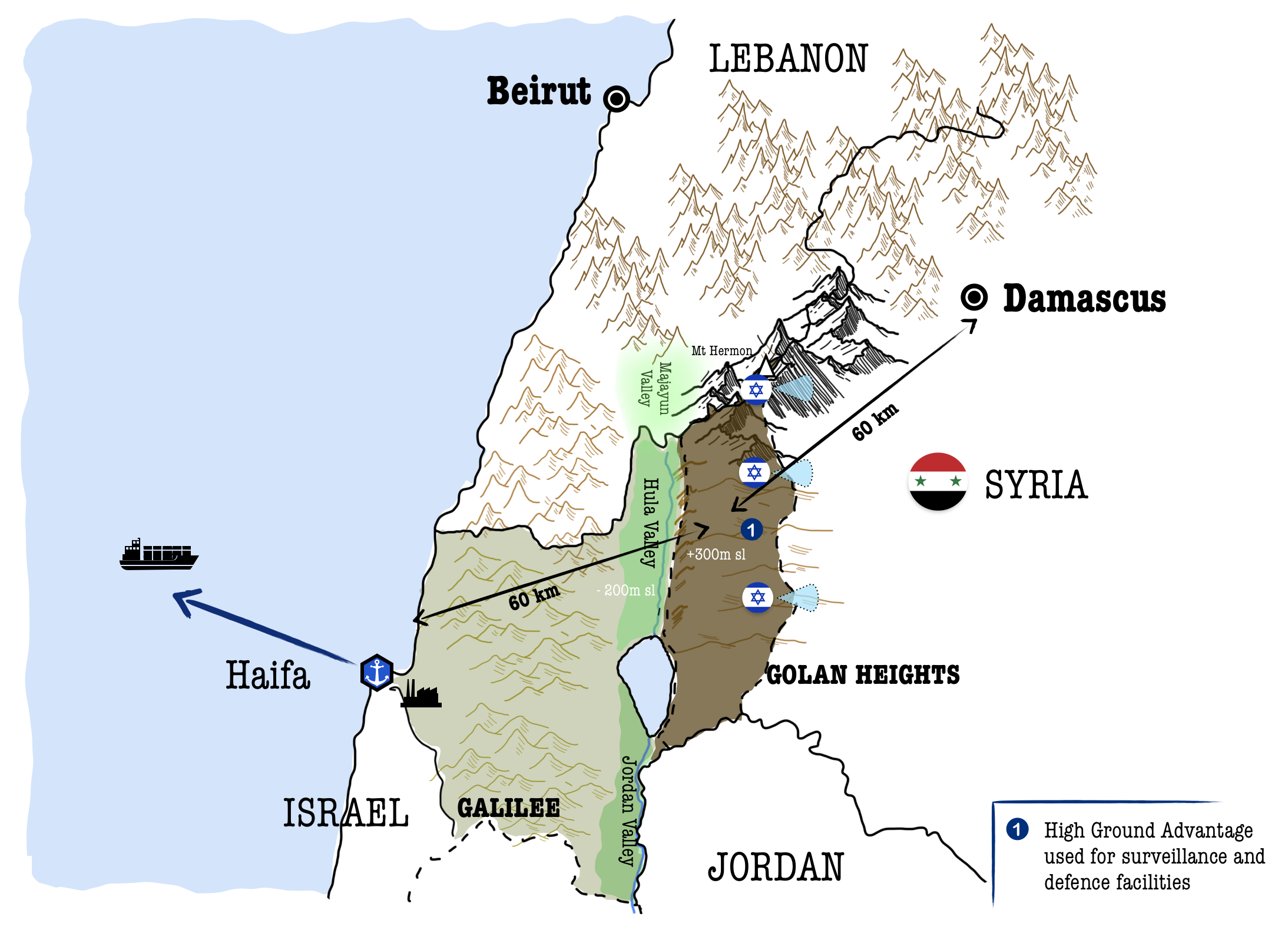
If the plateau were to be abandoned, both policymakers and military strategists agree unanimously that a defensive battle in the Hula Valley would be extremely difficult (Eiland, 2009, p.19).
5. The West Bank
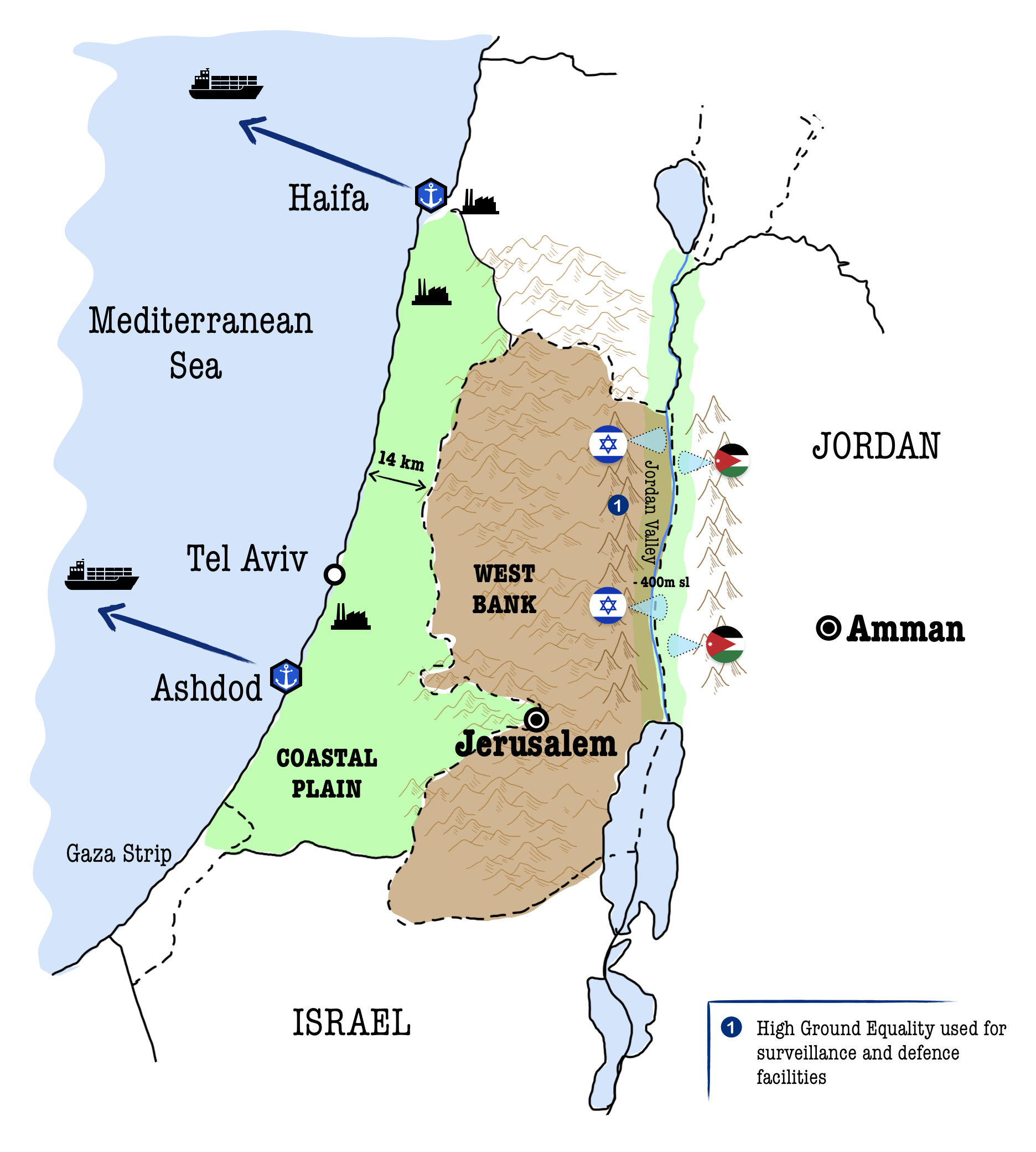
The West Bank stretches from the Coastal Plain to the shores of the Jordan River and the Dead Sea. Its terrain is predominantly mountainous, ranging from 500 m to over 1000 m in its west-central area. On the other hand, to the east, the Jordan Valley and the Dead Sea lie more than 400 m below sea level (Orni & Efrat,1977) (Map 6).
This strategic vantage point has historically been used by Jordan and the Arab Palestinians to launch attacks against Israel’s Coastal Plain (Mutawi, 2002).
“The neighboring Arab states and the Palestinians living within them continually expressed their goal of obliterating Israel, and for years following the 1949 armistice, Arabs made incursions into Israeli territory, ‘burning, marauding, stealing, and killing’” (Kramer, 2001).
In 1967, the Six-Day War enabled Israel to wrest the West Bank out of the hands of Jordan, which had retained its control since the end of the British Mandate.
Following the acquisition of this territory, Israel initiated the construction of settlements across the region. To date, the West Bank has about 500,000 Israeli inhabitants, known as settlers (Total population of Israel 2021, by district, n.d.).
Today’s position of the Israeli civil and military forces in the West Bank thus allows the Jewish state to have extensive control over the territory at the expense of the Palestinian Arabs and to prevent these types of attacks from taking place on Israeli territory.
As was pointed out by the Israeli Military Government’s expert on security during the Beit El case [H.C. 606/78, Ayub, Et al. v. Minister of Defence, et al.]
“part of the Government’s concept of security […] bases the security system inter alia on Jewish settlements. [...] In times of peace and tranquility these settlements mainly serve the need for ‘presence’ and control in vital areas, for maintaining observation and the like. Their importance increases particularly in wartime, when regular military forces are generally moved from their bases for operational needs and the said settlements form the principal element of ‘presence’ and security control in the areas in which they are located” (Playfair, 1988, p.418).
Furthermore, when considering the topography of the region, the control over the West Bank also mitigates Israel’s defensive vulnerabilities against an attack from the east. Before 1967, the Coastal Plain, the heartland of the Jewish state, was indeed highly exposed to such attacks.
By extending the border from the Coastal Plain to the Jordan Valley, Israel not only better secured its heartland but also gained a commanding position over the valley below, where today’s border with Jordan lies, enabling a more effective defensive position of its east flank (Map 6).
📌 Conclusions
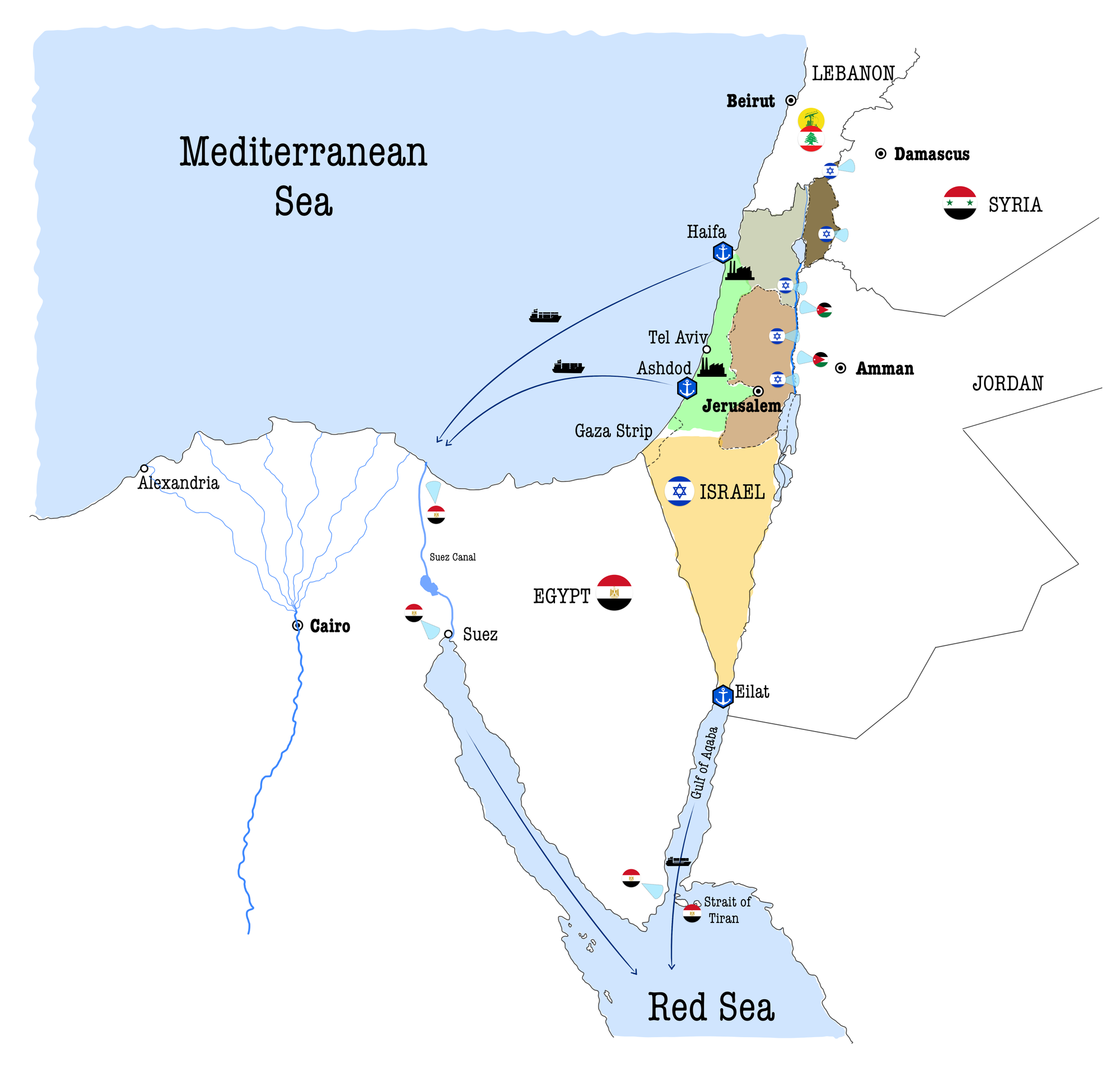
The geographical circumstances of Israel’s pre-1967 borders, as analysed in the article, posed distinct challenges from a strategic and defensive standpoint, primarily due to the absence of both strategic depth and advantageous high ground (Map 7).
- Israel’s strategic depth is constrained by its narrow geography, especially along the Coastal Plain, the nation’s heartland, where the country’s vital industries and about three-quarters of its population are concentrated. This region is merely 14 km wide at its narrowest point, making it extremely susceptible and vulnerable to potential attacks from the east. The same applies to the Galilee region, bordering Lebanon to the north and Syria to the east. It could even be argued that due to its slender dimensions, “the entire country is a frontier”, putting it entirely within easy enemy range (Dayan, 1955, p.250).
- Second, Israel’s original borders placed it at a tactical disadvantage, situated on low ground, while the neighbouring powers to the east enjoyed the advantage of high ground, historically used for surveillance and attack. Both the Golan plateau and the West Bank have this strategic advantage over the Coastal Plain and the Hula Valley in the Galilee.
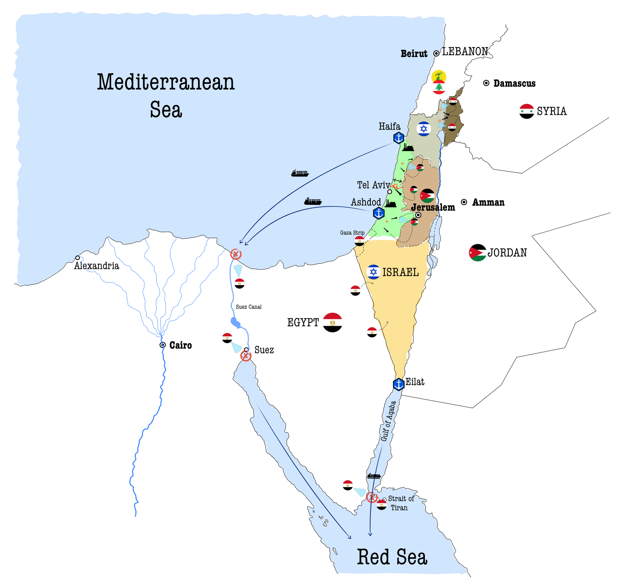
Following the 1967 war, during which it took control of the Golan Heights, the West Bank, and the Sinai Peninsula from its Arab neighbours, Syria, Jordan, and Egypt, respectively, Israel not only failed to return the conquered land, as it did with the Sinai to Egypt but also formally annexed the Golan Heights and continued to encourage Israeli settlements in the West Bank (Map 8).
Why does Israel continue to pursue this policy despite the disapproval of the international community?
References 📃
- Baron, O., Berman, O., & Gavious, A. (2018). A game between a terrorist and a passive defender. Production and Operations Management, 27(3), 433–457.
- Dayan, M. (1955). Israel’s border and security problems. Foreign Affairs, 33(2), 250–267.
- Eiland, G. (2009). Defensible Borders on the Golan Heights. Jerusalem Ctr Public Affairs.
- Eshel, D. (1997). The Golan Heights: A vital strategic asset for Israel. Israel Affairs, 3(3–4), 225–238.
- Euronews. (2023, October 23). The Iron Dome: How does Israel’s missile defence system work? https://www.euronews.com/next/2023/10/21/the-iron-dome-how-does-israels-missile-defence-system-work
- Gradus, Y., Razin, E., & Krakover, S. (1993). The industrial geography of Israel. Routledge.
- Inbar, E. (2011). Israeli Control of the Golan Heights: High Strategic and Moral Ground for Israel. Mideast Security and Policy Studies(90), 1–33.
- International Strategic Analysis. (2018, October 24). The Importance of Strategic Depth. https://www.isa-world.com/news/?tx_ttnews[tt_news]=442&tx_ttnews[backPid]=1&cHash=2fab7c50561ded287453afb408a82901
- Kramer, T. (2001). The Controversy of a Palestinian Right of Return to Israel. Ariz. J. Int’l & Comp. L., 18, 979.
- McKernan, B. (2023, October 7). Israel and Hamas at war after surprise attacks from Gaza Strip. The Guardian. https://www.theguardian.com/world/2023/oct/07/hamas-launches-surprise-attack-on-israel-as-palestinian-gunmen-reported-in-south
- Mutawi, S. A. (2002). Jordan in the 1967 war (1st pbk. ed). Cambridge University Press.
- Orni, E., & Efrat, E. (1977). Geography of Israel (3d rev. ed). Jewish Publication Society of America.
- Playfair, E. (1988). Israel’s Security Needs in the West Bank, Real and Contrived. Arab Studies Quarterly, 10(4), 406–423. JSTOR.
- Shapir, Y. (2013). Lessons from the iron dome. Military and Strategic Affairs, 5(1), 81–94.
- Total population of Israel 2021, by district. (n.d.). Statista. Retrieved 16 February 2024, from https://www.statista.com/statistics/1288905/total-population-of-israel-by-district/
- United Nations Office for the Coordination of Humanitarian Affairs—Occupied Palestinian territory | West Bank Access Restrictions | May 2023. (2023, May 26). United Nations Office for the Coordination of Humanitarian Affairs - Occupied Palestinian Territory. http://www.ochaopt.org/content/west-bank-access-restrictions-may-2023

