Medium Earth Orbit (MEO): An Overview
What is a Medium Earth Orbit? What do we use it for? Communication systems alongside every Global Navigation Satellite System (GNSS) are placed in this orbit. Why?

1. What is a Medium Earth Orbit (MEO)
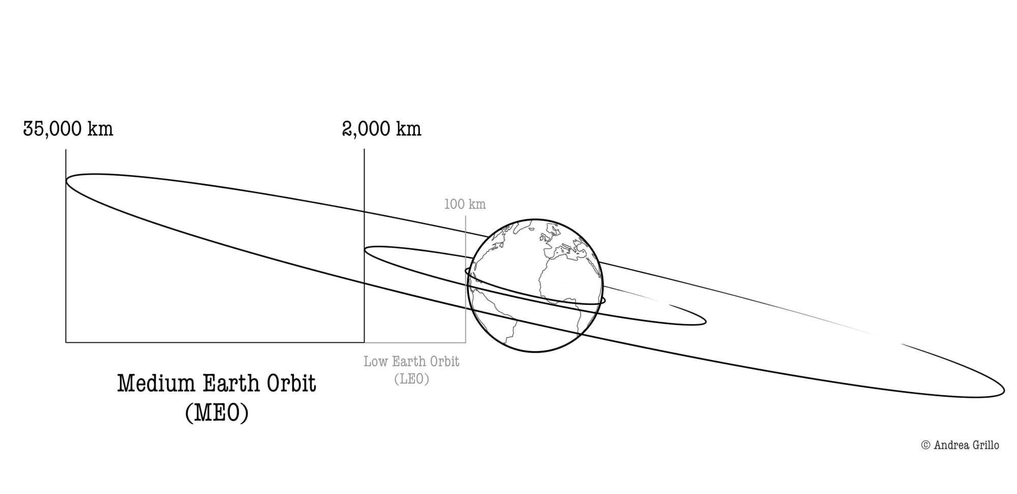
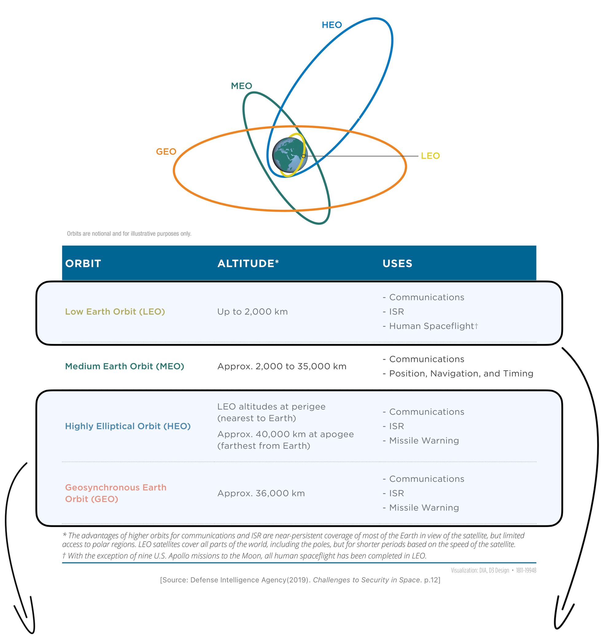
A Medium Earth Orbit (MEO) is an orbit with an altitude between 2,000 km and 35,000 km (Defense Intelligence Agency, 2019, p.12) (Figure 1).

At these altitudes, satellites must be equipped with radiation-hardened components to protect their computer systems from space weather, thus increasing their weight and consequently the cost of the launch.
Depending on their altitude, satellites in MEO perform between 14 and 2 complete orbits per day. The orbit that makes two revolutions in one day has an orbital period of 12 hours and is located at an altitude of about 20,000 km (Dolman, 2005, p.56).
MEOs are also referred to as Intermediate Circular Orbits (ICOs).
2. MEO Applications
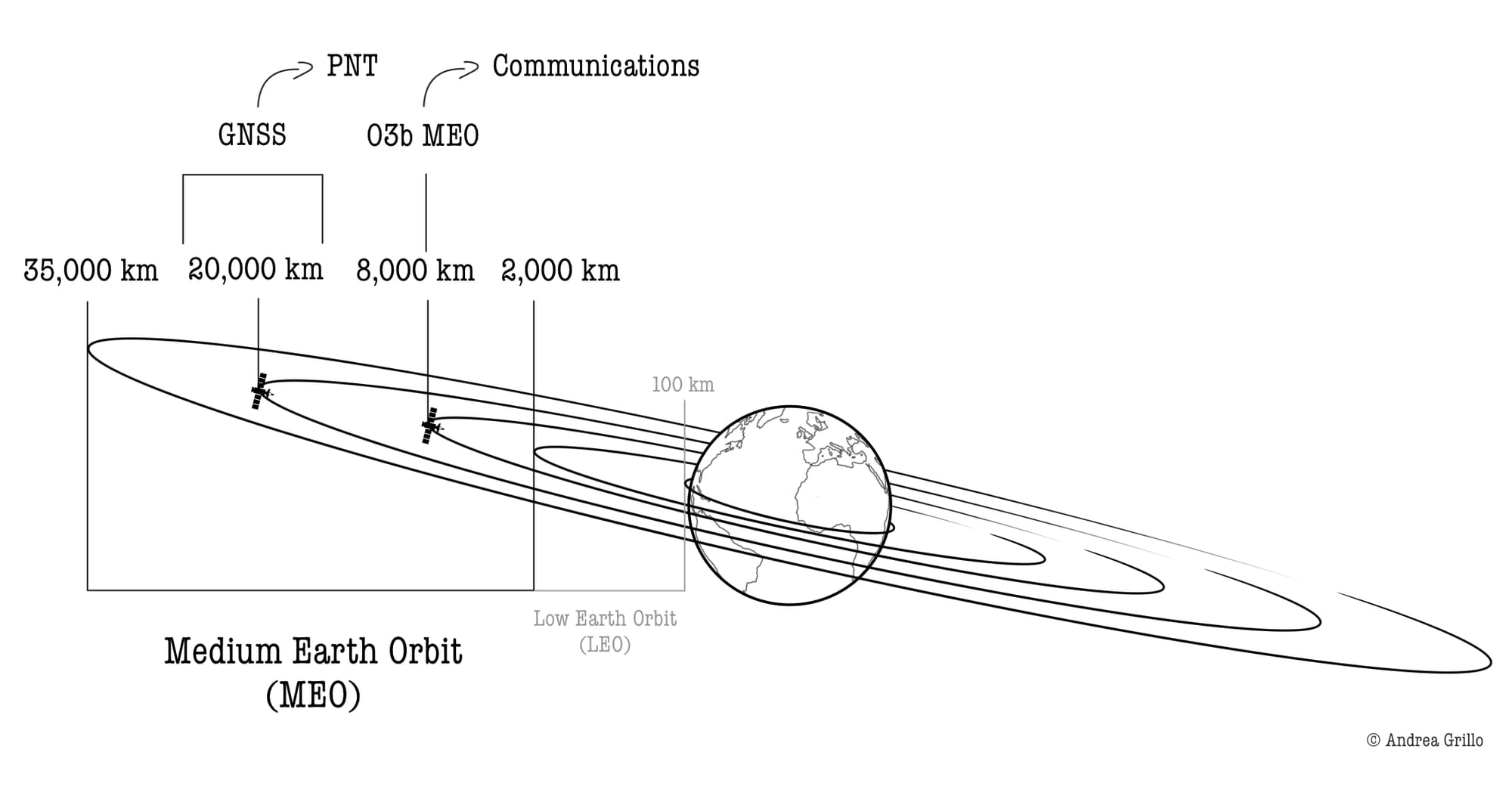
Medium Earth Orbits are used for Communication and Position, Navigation and Timing (PNT) services (Figure 2).
2.1. Communication services
The advantage of using such orbits compared to LEOs is that fewer satellites are needed for continuous global coverage, thus reducing the cost of the constellation (Wright et al., 2005, p.42).
The disadvantage is that the round-trip transmission time (RTT or latency) is slightly higher in MEO than in LEO. RTT in LEO stands at about 5 milliseconds, exemplified by the Iridium constellation with a specific value of 5.2 ms. On the other hand, the minimum RTT in MEO stands at 69 ms. Although these numbers may appear significant, it must be considered that a transmission spanning half the globe's circumference necessitates at least 67 ms across the Earth's surface, akin to the RTT in MEO, and allows for optimal voice communication (Wright et al., 2005, p.42).
2.2. Position, Navigation and Timing (PNT) services
PNT services are provided by a satellite constellation that transmits signals containing two pieces of information: the exact Time and Position of the satellite to the device to be geo-localised. The device receiving the signal, such as a smartphone or any GPS receiver – from at least 3 satellites (today 4) that are in range – processes T and P information and calculates its distance to each satellite, thus deducing its exact position via triangulation (Dick & Launius, 2007, p.177).
A navigation system thus requires a minimum of 3 satellites simultaneously visible to the user for accurate positioning, unlike a communication system, which only requires one. Placing such a constellation in MEO at an altitude of around 20,000 km allows for wider visibility, thus significantly reducing the number of satellites needed to ensure global coverage (Wright et al., 2005, p.42).

3. O3b MEO
O3b MEO derives its name from its aim: to serve the Other 3 billion people who, at that time, lacked or had limited access to stable internet connectivity (Yang, 2020, p.34).
The constellation, operated by SES Luxembourg, was established in 2014 and to date consists of 20 satellites in MEO at an altitude of 8000 km and 0° inclination (equatorial orbit) (O3b MEO, 2018). This orbital altitude ensures that O3b has a latency of only 150 ms compared to 600 ms of satellites in GEO (Yang, 2020, p.28,34).
O3b provides five services:
- O3bTrunk: High-speed, low-cost broadband access.
- O3bCell: Backhaul for 2G, 3G, and 4G services.
- O3bEnergy: Real-time monitoring for energy platforms.
- O3bMaritime: Broadband access with vessel tracking.
- O3bGovernment: Secure, low-latency communication for government and military use (Yang, 2020, p.34-35).
These services are delivered within an area spanning 50° north to 50° south of the equator for optimal coverage, thus reaching 96% of the world’s population, and reaching +/- 62° latitude with limited service (O3b MEO, 2018) (Figure 3).

4. Global Navigation Satellite System (GNSS)
A Global Navigation Satellite System (GNSS) is a specific Satellite Navigation System (SatNav) that uses PNT satellites in MEO to provide global geolocalisation.
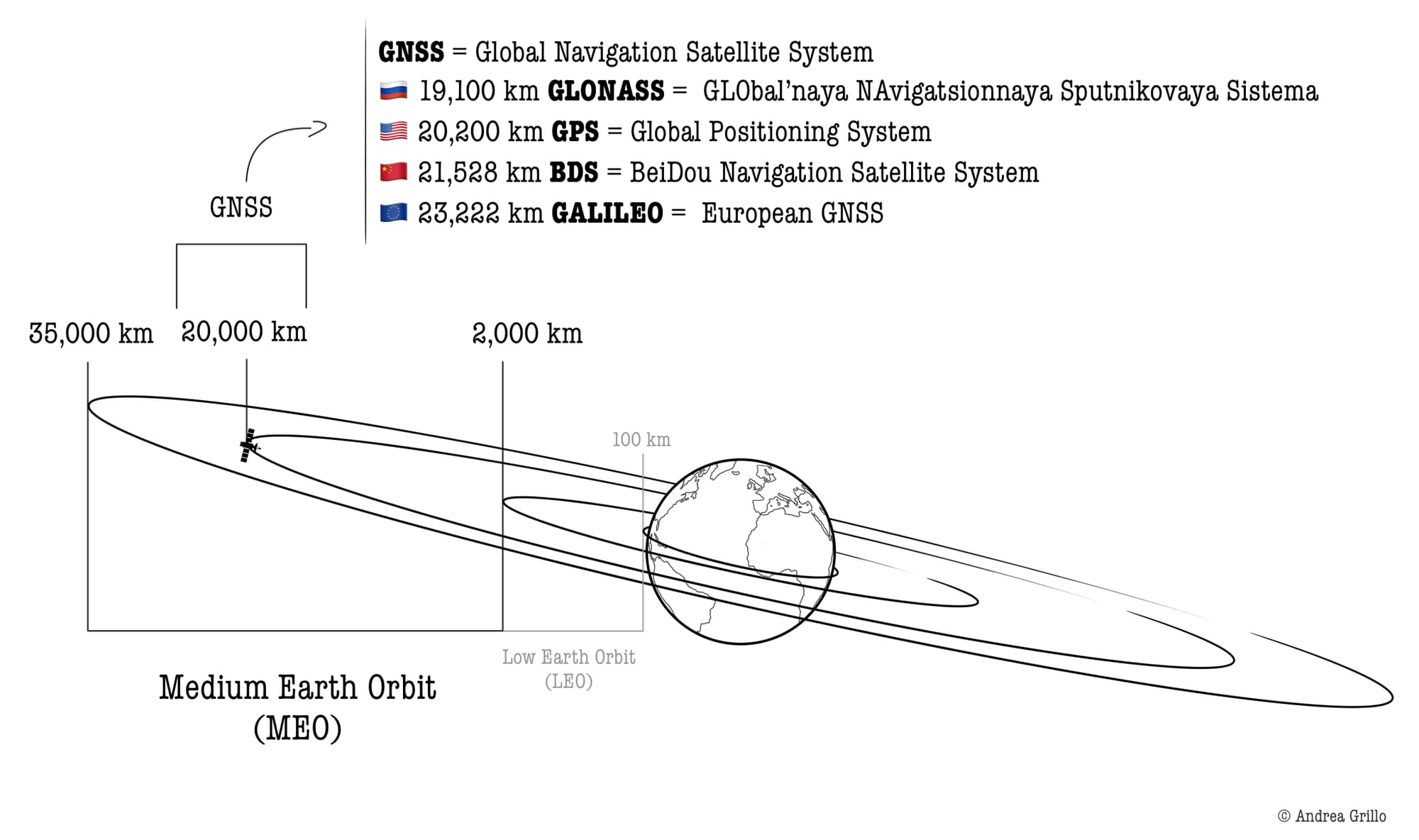
GNSSs use satellites located at an altitude of about 20,000 km that have an orbital period of about 12 hours and therefore make 2 revolutions per day (Figure 4).
Current GNSSs are:
- the American Global Positioning System (GPS), consisting of at least 24 operational US government satellites distributed in 6 orbital planes inclined 55° from the equator and located at an altitude of approximately 20,200 km;
- the Russian GLObal NAvigation Satellite System (GLONASS), consisting of 24 operational satellites in 3 orbital planes inclined 64°8' from the equator at an altitude of about 19,100 km;
- the European GNSS Galileo, composed of 30 satellites in 3 orbital planes inclined 56° and located at 23,222 km altitude. (Galileo Satellites, n.d.);
- the Chinese BeiDou, which has most of its satellites - 27 out of a total of 35 - placed in 3 orbital planes at an inclination of 55° and altitude of 21,528 km. The other 8 satellites are located in Geosynchronous orbits (Pan et al., 2019).

📌 Key Takeaways
- Medium Earth Orbits (MEOs), also called Intermediate Circular Orbits (ICOs), are placed between 2,000 km and 35,000 km above the Earth's surface, completing between 14 to 2 full orbits per day. They require satellites to be equipped with radiation-hardened components due to space weather.
- MEO Operations:
- MEO communications require a reduced number of satellites for global coverage compared to LEOs, despite the slightly higher latency.
- PNT services rely on signals from at least 3 satellites for accurate geo-localisation through triangulation. Placing the PTN constellation in MEOs (20,000 km altitude) optimises coverage while minimising the number of satellites needed.
- O3b MEO Constellation: With 20 satellites at an altitude of 8,000 km and 0° inclination (equatorial orbit), O3b achieves a low latency of 150 ms, covering +/- 50° latitude, thus reaching 96% of the global population. Its services include broadband access, backhaul for mobile services, energy platform monitoring, maritime broadband, and secure communication for government use. Services
- Global Navigation Satellite System (GNSS): GNSS relies on PTN satellite constellation in MEO (around 20,000 km altitude) to offer precise global positioning and navigation. Current GNSS systems include the US GPS, the Russian GLONASS, the European Galileo, and the Chinese BeiDou.
References 📃
- Defense Intelligence Agency. (2019). Challenges to Security in Space.
- Dick, S. J., & Launius, R. D. (2007). Societal impact of spaceflight. National Aeronautics and Space Administration (NASA).
- Dolman, E. C. (2005). Astropolitik: Classical geopolitics in the space age. Routledge.
- Galileo satellites. (n.d.). The European Space Agency. Retrieved 29 April 2024, from https://www.esa.int/Applications/Satellite_navigation/Galileo/Galileo_satellites
- O3b MEO. (2018, October 31). SES | Satellite Communication Service Provider. https://www.ses.com/our-coverage/o3b-meo
- Pan, L., Zhang, X., Li, X., Li, X., Lu, C., Liu, J., & Wang, Q. (2019). Satellite availability and point positioning accuracy evaluation on a global scale for integration of GPS, GLONASS, BeiDou and Galileo. Advances in Space Research, 63(9), 2696–2710. https://doi.org/10.1016/j.asr.2017.07.029
- Wright, D., Grego, L., & Gronlund, L. (2005). The physics of space security. A Reference Manual.
- Yang, X. (2020). Low earth orbit (LEO) mega constellations-satellite and terrestrial integrated communication networks. University of Surrey. https://doi.org/10.15126/thesis.00850382
Keep Learning


